Historical Background
Discussion about building a regional subway system for the Washington, DC metropolitan area began in the 1950’s, and in 1959, the National Capital Transportation Agency released a Mass Transportation Survey report to President Eisenhower that recommended three things 1:
- Rail rapid transit must be provided in the Nation’s Capital regardless of the size of the region’s highway system.
- A federal agency should be established to oversee the transportation system in Washington.
- The District of Columbia, Maryland, and Virginia must be brought together into a legal consortium to deal with transportation issues of a regional nature.
The NCTA presented a study to President Kennedy in 1962 that recommended an extensive freeway system, improved bus service, and an 83-mile rapid transit system encompassing 65 stations 2.
This ultimately led to the formation of the Washington Metropolitan Area Transit Authority (WMATA) in 1967. The purpose of the new agency was to plan, develop, finance, and operate a regional transit system that included the District of Columbia and portions of Maryland and Virginia. In 1968, the WMATA ultimately proposed a 98-mile regional system with 83 stations. With minor modifications, this became the model for Metro’s construction over the following three decades 3.
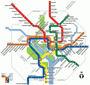
Groundbreaking took place on December 9, 1969 at what would become the Judiciary Square station on the Red Line, and the first five stations of the system began passenger service in March 1976 4. Over the following quarter-century, the Metro system was expanded, with an average of 3.8 miles of route and roughly three stations added per year. On January 13, 2001, the southern end of the Green Line opened between the Anacostia and Branch Avenue stations, completing the 1968 master plan 5.
Since then, the system has been expanded beyond the original 1968 mater plan, with the Blue Line extended to Largo Town Center, a new Red Line station at New York Avenue, and a new Silver Line to Dulles Airport currently under construction. As of this writing, the Metro system encompasses 106 route miles and 85 stations 6.
Operations
The Washington Metro is a fully grade-separated, heavy rail rapid transit system, with a combination of underground, surface, and above-ground stations. Trains vary in length from two cars to eight cars long, and utilize Automatic Train Operation (ATO). Under ATO, the trains are semi-automated, with on-board computers responsible for governing train speed and stopping locations at platforms. Each train has a human operator to close doors, make announcements, and oversee operations. The operator can manually drive the train if needed.
Fare collection is via prepaid fare cards and unlimited-ride passes, which are distributed via farecard vending machines in stations, and swiped at fare gates upon entering and leaving the system. The fare structure is distance-based, with differing fares charged depending on the number of zones traveled. A surcharge is added for peak periods.
This amateur video shows a 4-car Metro train entering and departing Union Station in 1996:
Station Architecture
At the time the Washington Metro system was proposed, the word “subway” immediately evoked images of dark, filthy, and dangerous stations in New York and Chicago. Meanwhile, with the Cold War at its peak, Moscow boasted of grandiose stations with elaborate beaux-arts carvings and chandeliers.
In a somewhat unusual move, the WMATA hired a single architecture firm — Harry Weese Associates of Chicago — to design every station of the system. Although there are some subtle variations between stations, this approach gives the entire system a very unified appearance.
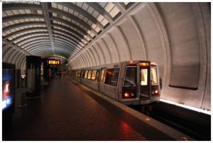
The typical underground station on the Washington Metro features a dramatic, column-free space spanned by a cast concrete barrel vault ceiling that evokes but does not mimic the stately government buildings and monuments found throughout the District. Advertising is kept to a tasteful minimum, and is confined to backlit display panels placed at strategic locations throughout the station. The color palette is kept simple and subdued, with the platform floors composed of red quarry tile and gray granite edges, dark brown signage and fixtures, and gray concrete for the station shell. Fare control is located on mezzanines that appear to float within the station shell, with curved surfaces guiding circulation patterns and avoiding dark corners. From the mezzanine, the entire station is visible at a glance, and wayfinding becomes self-evident, avoiding the warren of passageways often found on older systems. Access to the surface is typically via banks of escalators instead of stairs.
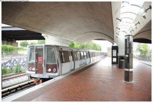
The above-ground stations are simpler in design, with a concrete gull-wing roof providing protection from the elements for at least a portion of the platform. A central skylight forms a spine down the length of the roof, and provides natural daylighting to the platform below. Fare control is usually located in a concourse below the platform level, which opens directly to the street. The palette of colors and materials is similar to that found in the underground stations.
Lessons for Cincinnati
By the time the initial 83-mile rapid transit proposal was presented to President Kennedy in 1962, the population of the Washington, DC metropolitan area was less than 2 million people 7, roughly comparable to the population of the Greater Cincinnati and Northern Kentucky region today. Additionally, the Washington Metro provides service to the District of Columbia, Maryland, and Virginia, providing a model for how a regional transit authority may be formed to provide transit in Southwestern Ohio, Northern Kentucky, and Southeastern Indiana.
Since the Washington Metro began operations it has grown into the second-largest rapid transit system in the US in terms of ridership. Despite being comparable in size to the Chicago ‘L’ in terms of route miles, the Metro system carries almost 1.5 times as many passengers per year 8.
The architectural design of the system has won numerous accolades, and is included in the American Institute of Architects “America’s Favorite Architecture” list 9. The Metro system has become a source of civic pride, with the Fodor’s Travel Guide describing it as “one of the country’s cleanest and safest subway systems” 10, and the tourist side TheDistrict.com featuring a Metro station prominently on its main page 11. Since Metro’s inception, over $25 billion in development has taken place near Metro rail stations 12.
Some ideas from the Washington Metro that should be considered for a regional rail system in Greater Cincinnati:
- A regional transit authority that spans state boundaries.
- Fully grade-separated rail rights-of-way to enhance travel speeds.
- Architecturally-distinctive station facilities that are easy to maintain and pleasing to the public.
- A zone-based fare system with peak period surcharges that encourages development near the urban core, and off-peak travel.
Further Reading
NYCsubway.org: Washington Metro
Notes
- Wayne R. Thompson, Metro at 25: Celebrating the Past. Building the Future, Washington: Washington Metropolitan Area Transit Authority, 2001, p. 9.
- Thompson, p. 12.
- Zachary Schrag, Building the Washington Metro: An Online Exhibit, “The Adopted Regional System, 1966-1968”, http://chnm.gmu.edu/metro/plan2.html [accessed 19 February 2010].
- Thompson, p. 1.
- Wayne Whitehorne and Mark Greenwald, NYCsubway.org: Washington Metro, http://world.nycsubway.org/us/washdc/index.html [accessed 19 February 2010].
- Whitehorne and Greenwald.
- Population Reference Bureau, “Immigration Into Washington, D.C. Since 1950/ U.S. Census Bureau. 1950, 1960, 1970, 1980, 1990, and 2000 Censuses”, PRB.org, http://www.prb.org/Content/NavigationMenu/PRB/Educators/DC_Metro_Data/Immigration/immig_hndts.pdf [accessed 19 February 2010].
- American Public Transit Association (APTA), “Transit Ridership Report: Third Quarter 2009”, http://www.apta.com/resources/statistics/Documents/Ridership/2009_q3_ridership_APTA.pdf [accessed 19 February 2010]
- American Institute of Architects, “America’s Favorite Architecture: Washington, DC Metro”, http://favoritearchitecture.org/afa150.php [accessed 19 February 2010].
- Fodor’s Travel Guides, “Washington, DC Travel Tips: By Metro”, http://www.fodors.com/world/north-america/usa/district-of-columbia/washington-dc/travel-tip_2046906.html [accessed 19 February 2010].
- TheDistrict.com, “Washington, DC visitor Information”, http://www.thedistrict.com/visitor_info.cfm [accessed 19 February 2010].
- Washington Metropolitan Area Transit Authority Planning Development, and Real Estate Committee, “Capital Needs Inventory: FY 2011 – FY 2020”, 25 September 2008, p. 6.


